
Hurricanes
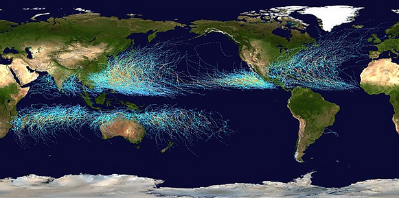
Map of the cumulative tracks of all tropical cyclones during the 1985–2005 time period. The Pacific Ocean west of the International Date Line sees more tropical cyclones than any other basin, while there is almost no activity in the Atlantic Ocean south of the Equator.
The majority of the tropical cyclones form between 10 and 30 degrees of latitude away of the equator. 87% Forms no further away than 20 degrees north or south. Because the Coriolis effect initiates and maintains their rotation, tropical cyclones rarely form or move within 5 degrees of the equator, where the effect is weakest. However, it is still possible for tropical systems to form within this boundary as Cyclone Agni and Tropical Storm Vamei did in 2004 and 2010, respectively.
One degree latitude is approximately 111 kilometers, so there is a band of 10 degrees north to 10 degrees south of the equator, which is 20 x 111 = 2220 kilometers, where the risk of ‘meeting’ an hurricane is fairly low.
I'm a paragraph. Click here to add your own text and edit me. I’m a great place for you to tell a story and let your users know a little more about you.
